Type 2 Diabetic. Cyclist Flâneur.   Coffeeneur.    Errandoneur
A bike / map geek with a gadget obsession and a high-viz fetish.
Showing posts with label ohiopyle. Show all posts

Monday, October 22, 2012

Connellsville to Confluence, Fog to Sun, New Pedals

10.22.12 58M
Today I got to complete a ride I started last week with S. but didn't feel up to completing, from Connellsville PA through Ohiopyle to Confluence, round-trip.

The weather started dark and cold, turned foggy-cloudy and cold, and eventually turned sunny and blue. Met S. at the Bastille at 0600, got to Connellsville and out on the trail at 0740 in the early daylight, with low clouds and fog in the river valley. It was quite cold, probably 38F, and I wore pretty much my winter kit: long pants, jacket over wool sweater over a jersey, my winter-weight Wombat gloves, and a very thin ear liner.


As the ride started it was cold and we were glad just to warm up, but after an hour we saw that the clouds were lifting and after a while some blue holes were visible in the overcast and the temperatures started to ride slowly.


We stopped briefly about twelve miles in to the ride, and just as we approached Ohiopyle the weather started clearing but it was still pretty chilly. We went into the Ohiopyle general store for some Italian wedding soup (it's a consistent hit) and that went a long way toward making things better).

We came out of the store and I switched to lighter full-fingered gloves and lost the ear-liners, and then about halfway to Confluence I took off a layer and shed the jacket and the long pants.

Approaching Confluence we were surprised to encounter two murals on the GAP by the Confluence Creative Arts Center, they were very nice and it doesn't surprise me that once again, Confluence is at the vanguard of what trail towns are doing to appeal to through-riders.


We rode to Confluence's town square and I stopped at Confluence Cyclery, it's an excellent shop with very nice people; I've been looking for a new pair of platform pedals and they had just what I wanted, great find.

We continued to Sweetie's Bakery and were crushed, just crestfallen to learn that they've gone to an off-season schedule and they're only open on weekends. No pastries, no biscotti? An absolute crisis!

Departed Confluence on the reverse course and with the sun up and the day warming, more people were out on the trail. I switched to summer gloves to complete the wardrobe tour-day-force. Stopped for a snack out of the panniers about halfway back to Ohiopyle.


In Ohiopyle, checked in at the Bakery for a bagel to go. Back on the trail, which was now dried up from this morning's conditions. There were more people out on the trail.

In the last few miles before Connellsville, the sun was getting lower again and we began to see the opposite river bank's reflection in the river.


We watched a big deer cross the river then bound up the ridge across our path, very impressive.

Monday, March 26, 2012

Connellsville Ohiopyle Confluence

03/26/12 241# 59m 44F


Rode 59 miles on the Great Allegheny Passage from Connellsville through Ohiopyle to Confluence and back, a great ride. This is sort of a "showcase" route with a lot of great and varied scenery, good towns with lots of support available - it's a destination ride rather than spending the day in a "green tunnel" that takes on the attributes of an "endless swimming pool'.

S,S, and I rendezvoused with B at the Connellsville Bottling Company trailhead, and rode through the amazing barrier-protected bike boulevard they've built, stopping at the only traffic light on the GAP between Pittsburgh and Cumberland, and then joining the trail. Connellsville's commitment to the bike economy is unquestionable, as shown by their signature artwork representing the transition from coke ovens to bike wheels.


It had rained the three previous days, and I was apprehensive that the trail might have been soft but it was in excellent condition. There was quite a lot of waterfalls, more than I've seen there before, probably resulting from the rainfall. The combination of no leaves and lots of water combined to good effect.
The scenery was wintery: the trees were stark and bare, there was a lot of visibility through the woods, it was a view of this trail that I had not seen before.


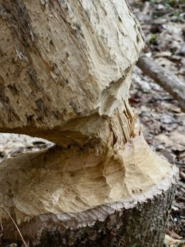
In the photo above you'll see a tree on the right that started to fall across the trail until it was caught by the trees on the left. If you were able to look closely at the base of that all-but-fallen tree, you'd see the photo on the right. IANAN (I am not a Naturalist) but that looks like the work of either a critter with sharp teeth (a beaver?) or a very patient person with a Dremel tool.

We rode into Ohiopyle, known as the second-best rest stop on the GAP (after West Newton Station, of course) and made our way to the general store for a snack. Cups of wedding soup were just what the day's temperatures called for, it was very good. When we got back to the trail B departed our group to return to Connellsville for other obligations.

We continued to Confluence, trail conditions were great. As we pulled into town our first attempts at lunch were unsuccessful; River's Edge doesn't open for the season for a few more weeks, and Sister's Cafe was closing for the day.

We did meet two bicyclists travelling from DC to Pittsburgh, one had a Surly and the other was riding "rack-free" using a frame rack in the triangle, a wedge pack, and a backpack. She said the space constraints forced continuous attention to economy, and that she was riding with a backpack in order to rring her sleeping bag along, but she enjoyed riding the bike without the parasitic weight of the racks.

Stopped at the most excellent Confluence Cyclery to look around and ask advice, and they recommended we go to Sweetie's Bakery and Cafe for lunch which was very good advice. It's about six blocks off the town square, there's a surprisingly large bakery with a dining room and an adjacent pizzeria, and if you get pizza you're welcome to use the bakery dining room. Very good food; I had two slices of pizza and a cocoanut almond biscotti, delicious.

When it was time to go we reversed and headed west and into the wind. On the first leg we were climbing with a tailwind, and on the second leg we were descending with a headwind. While we were eating the overcast had cleared away and the sun was shining, which was very nice. The conditions on the second half, with the sun shining and a slighter higher temp (45F) later in the day, were almost ideal and preferable to the morning.

We rode to Ohiopyle and saw more people on the trail this time, either because of the time of day or the warmer temps. Back to the general store and this time I fortified myself with an ice cream cone (overly generous) and a Starbucks in a bottle, figuring to load up on sugar, fat and caffeine for the last leg.

We had a nice ride back to Connellsville and got a bit of headwind practice in. We had taken an unhurried ride and unrushed stops, so this took most of the day and it was a very nice ride.

Sunday, July 31, 2011

Overnight Bike Trip - S36O - Ohiopyle to Cumberland

Rode 75 miles in 7h15m (start-to-stop clock time), 5h23m (pedal-turning riding time).


Started at Ohiopyle at 1230. It's very crowded there in a summer Sunday afternoon, lots of people, lines for restrooms, etc. I couldn't find any obvious overnight parking so I used a relatively out of the way spot and left my car in it, hoping for the best.

The first leg to Confluence was crowded and congested, it was good to see all sorts of riders on all sorts of bikes. It was a mostly flat 11 miles to Confluence.

Confluence had a lot of people on bikes, mostly on the River's Edge - to - Town Square axis. The Confluence Cyclery (bike shop) offers free water, rest rooms, and an internet terminal, which is pretty cool.

Sidebar rant: I think that businesses that provide a sink or a faucet for free, and cool or bottled water for a fee, are supporting their customers and providing an ethical service. Businesses along a bike trail that only provide water for a fee are a bit too mercenary for me. When a place offers free water, I'll always leave a tip that exceeds what the same amount of bottled water would have cost, just to show that I appreciate their good will.

The cellphone coverage in Confluence is tremendously improved, another sign of the increased trail traffic affecting local conditions. Stopped at Sister's Cafe for a grilled ham-and-cheese sandwich (excellent). While I was in Confluence I kept an eye out for trail cartographer Bill Metzger, sort of like you'd keep an eye out for the Pope if you were touring the Vatican, but there was no Bill sighting.

The second leg to Rockwood saw the path pitch uphill a bit. It retrospect this may be the steepest segment of the admittedly friendly climb. Beautiful river views, I especially enjoy the ride around the Pinkerton Horn. I still saw other riders every five minutes or so. Entering the Rockwood trailhead there's a small "welcome" shack, and there's a low-power cellphone repeater under the eaves, which is very nice.

In Rockwood there's a trailside bike shop, I stopped in to check it out. They had a surprising amount of bike gear and water for sale (none for free). Rode into town for the Rockwood Opera House, had some ice cream and a Coke.

Departing Rockwood for Meyersdale the pitch seemed to level off. There was a downed tree across the path. Later I was very pleased to see two riders in the distance who turned out to be Pam and Bill Metzger, and it was a treat to get to spend a few minutes with them. They're both excellent people. Bill was riding his recumbent hand-crank bicycle, and Pam was riding a long-wheelbase recumbant, I think it was a Rans.


Saw the windmill farms and came upon the Salisbury Viaduct, wow wow wow what a view. It looks like the world was built to be seen from up there. The trail from the viaduct into Meyersdale is tremendously improved over the first time I was here. I decided to skip my stop in Meyersdale and press on to Frostburg, since at this late hour of the day my fave stop in Meyersdale (the GI Dayroom) would be closed.

Departing Meyersdale it was a nice climb to the Continental Divide followed by a wonderful descent. Rode through the (lighted) Savage Tunnel, the Mason-Dixon line, and the Borden Tunnel.

I was looking forward to stopping at Frostburg and marked one of the town's steeples above the treeline, but I missed the turn to the train station and ended up riding beyond the town. Since I'd skipped Meyersdale and now missed Frostburg, I ate a few powerbars and continued on to Cumberland.

This is the first time I've ridden the new trail between Frostburg and Cumberland, it's a very nice trail and the route into the city was car-free. I did lose my Droid's GPS signal on the east side of the Continental Divide, and I think a dedicated GPS with a twin-loop antenna would have done the job better.

There's a new hotel right on the trail in Cumberland, a Fairfield Marriott, it's a bit pricy but it is in a perfect location. They seem to grok the trail business, they had no objection to a bike in the room, and they even have a trailside bike washing station (a hose on a concrete pad, it could use an air pump, but it's a nice touch).

I got out of the shower at 8pm, just as the local restaurants close on a Sunday evening. I wound up eating at the world famous Queen City Creamery a few blocks away, which always has good food.

This was a really nice ride. The trail is in excellent condition, the bike did well (thanks to Ambridge Bike Shop on Friday), the weather was perfect, just good all around.

Friday, June 3, 2011

Rockwood to West Newton Bike Trip, Day Two

11-06-03 #???
74 miles, 5h35m
A few words about the Rockwood Hostel. It was great, in terms of basic shelter and showers for less than $30. Wifi, cable TV, coin-operated laundry; it was all good. I imagine your experience will vary with the quality of people you find yourself rooming with.

Suggestions for the Hostel: it would be great to have a floor pump, and it would be great to have individual lockers you could secure valuables in. I believe there's going to be Pittsburgh people using the Rockwood Hostel as a base for a 3-day trip: (1) West Newton to Rockwood, (2) Rockwood east to Cumberland and back, and (3) Rockwood back to West Newton. The qualities of the GAP are so far superior to the C&O that this sort of a 3-day trip, at less then $30/night for lodging, makes sense.

It was a bit brisk at wakeup, about 48F. We repacked the bikes and departed Rockwood, planning on eating breakfast 19 miles down the trail at Sister's in Confluence. This was a mistake for me, I should have eaten first, so I got dizzy and we ended up stopping so I could eat and stabilize the blood sugar.

As we rode into Confluence, we re-entered cellphone coverage and our phones beeped and told us we had messages and missed calls. We had an excellent breakfast as Sister's Cafe, as expected, and we sat in the town square and returned phone calls.

We rode into Ohiopyle and took a break there, then we rode to Connellsville, bought lunch at Sheetz, and ate it at the park. I took a long break after I ate and that worked real well for me.

I find that I'm somewhat low energy after I've eaten, and between 40minutes and 55minutes after I eat I get real low energy, and at 55 minutes something clicks and I feel good to go again.

We rode on to West Newton uneventfully, covering 74 miles in 5h35 minutes. That's a good time, recognizing that it was downhill (yesterday at 5h55m was climbing) and that today was our second day on the bike.

Lessons Learned:
  • Can't ride without breakfast
  • I need to wait an hour after I eat a meal, just like my mother always told me about waiting an hour before I swam
  • Size matters in twisting tools, and my mini-tool doesn't provide a sufficient arm-length for torque
  • Seventy miles is my new "perfect daily distance".


We saw a lot of people traveling with overnight loads, several recumbents, several Bob-Trailers. We encountered deer on the trail three different times, and I ran over one two-foot snake before I realized it.