Type 2 Diabetic. Cyclist Flâneur.   Coffeeneur.    Errandoneur
A bike / map geek with a gadget obsession and a high-viz fetish.
Showing posts with label VLNUS. Show all posts

Friday, January 1, 2016

Icycle Bicycle 2016; Cyclops Bike Headlight

1.1.2016
10m
mtd:10 ytd:10
If it's New Year's Day it's also Icycle Bicycle time. This year the ride started at 1100, which I think is a bit later than previous years. It was a good weather day: 30F, dry, light blowing snow. It was a bit windy.

Although this is an "obey the law, stop at red lights until they turn green" event, this is also an uber-casual ride as far as route and distances go. I love the way Jim Logan described it on Facebook:
The basic concept is we are riding down to the west end bridge and loop back. We are all adults, so pick your own ride. As soon as you turn around it will feel warmer. So turn around if you get too cold. The course is to the 16th st bridge up the Allegheny. If you want to get back faster, use the Fort Duquesne walkway through Point State Park. If you are faster want to go farther, go to the 35th st bridge. Or the 40th. Or so on.


Photo by Lance Letterio

The nice folks at REI put out some cookies and hot chocolate. My wife Karen and I met RC at Big Dog Coffee before the ride. After the start, we rode northwest along Carson Street and crossed the West End bridge. Karen and I deviated from the route to cross the Roberto Clemente bridge. Market Square, Blvd of the Allies, Jail Trail, back to base. A great ride as it always is, a chance to see a lot of compagnon de route (which is to say, fellow travelers) and exchange good will at a time some folks are still recovering from the previous night.

Got into surfing some FaceBook, got into a discussion of front-fork mounts for lights. Ended up looking at this 1900 US patent, for a rig that turns the front headlight left-or-right when the bike turns, so that the beam slightly inside the curve and illuminates where you're going rather than where you're pointed now.


I think I could implement this on my bike, it would be pretty cool.

This is, I think, the same function as the center Cyclops headlight specified in the Tucker car design, which had the adjusting/dynamic headlamp at the center of a three-bulb array:


Kind of interesting that a revolutionary and ahead-of-its-time 1950 innovation comes from the bicycle realm in 1900.


Tuesday, January 31, 2012

Neville Island to McKeesport


01/31/12 49m
Magnificent day, started at 48F and ended the ride at 60F, winds out of the west. Short pants, UA ColdGear and a YJA jacket, light gloves.

Rode from the RMU hockey complex south along Neville Island then via Route 51 through McKees Rocks, continuing on to the West End and Station Square. Joined the Station Square Trail to Southside Works, then went "roadie" onto Route 837 South to get past the trail closure at Keystone Metals / Sandcastle.

Riding on 837 is a thrilling experience, and the drivers were very nice. I did have one fool yell "get off the road" to me at the 837/885 cloverleaf, which is built like a highway interchange; I attribute it to their riding around with their car windows open on a mild day.

Speaking of which, fascinating piece on Why Some People (drivers) Get Angry at Bicyclists. He argues that bicyclists are the Other, just like gypsies or immigrants, and so they are easily targeted by those who need to disapprove of another group to assuage their own insecurities, and he further suggests that the very act of cycling is perceived by the Angry person as a refutation of their (car-based) lifestyle, which makes them... angry. I'm not sure if these generalizations about angry drivers are any more valid than generalizations about punk bicyclists.

Continued on 837 through Homestead, where I took the photo to the right. There is quite a bit of street art in Homestead but I haven't found any large murals yet. It was interesting that (again) the current painting was layered over a previous painted advertisement. VLNUS.

In Homestead I turned left on Amity Street to enter the Waterfront Complex. What a remarkable difference from one side of the tracks to the other. From Amity Street I went directly behind the Eat N'Park onto the Steel Valley Trail.

The dirt-surface trail that runs through the Waterfront shows clear signs of maintenance since I was last through there in the fall. As I came around the Pump House I saw a few people taking bikes off cars and getting ready to ride.

I rode the bike lanes around Mahumnahumna? Steel and joined the paved trail that runs below Kennywood. There were quite a few bicyclists out on this section of the trail, including one "ambassador" that I see every time I'm out there.

I stopped in the middle of the Riverton Bike Bridge, and took the photo at the top of this post. It's a beautiful spot.

I turned around to ride north at about 2pm. I don't know whether it was the time of day or the balmy temperatures, but there were quite a few people out on the trail. Same route in reverse; north along the Steel Valley Trail, out on Route 837 to the FBI / Homeland Security complex, and back on the trails.

At South Side Works (SSWx?) I noticed that workers were assembled a gazebo on the plaza adjacent to HofBrauHaus. It will be great when that trail segment opens, I have to imagine the American Eagle people are getting tired of dodging bicyclists.

Riding north there continued to be a lot of people on the trail. Station Square, West End Circle, McKees Rocks, and Neville Island.

Neville Island is a barren, industrial place and I love it. It's flat, paved, good shoulders and excellent sight lines; there's a Subway and some big parking lots at the RMU Hockey Complex.

My computer showed 49.8 miles in 3h38m, so I figure it's 49. I had planned to ride 50, but I wasn't going to get back on the bike for another mile; that'll be another day.


Today's mileage put me at 318 miles for January 2012, which puts my average miles/day at 10 which is excellent for Me in January. In 2011 I didn't have 300 miles until March 18th.

Lest I become smug, the blog titled I Love Danny Chew, dedicated to Pittsburgh bicyclist Danny Chew, brings news that his January 2012 mileage is over 1000 miles. Incredible.

Friday, January 27, 2012

Ancient Geoglyphs Explained By Baltimore Bicyclist?

01/27/12 #236 0m
PacTom7 is a website documenting Pittsburgh runner Tom's effort to travel over every single bit of paved street in Pittsburgh, running through the city's grid like a PacMan character (hence, PacTom). He tracks every run with a GPS and uses his quest as a tool for continually changing routes.

He produces remarkable artwork with his GPS data:


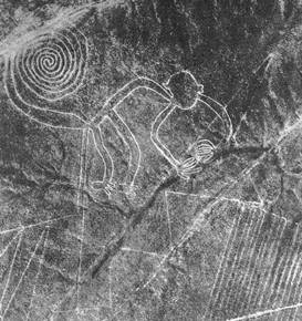
There is very little new under the sun (VLNUS); using terrain to create artwork that shows up on maps has been around. Geoglyphs are large designs or motifs produced on the ground, typically formed by rocks or durable elements of the geography, such as stones, stone fragments, gravel, or earth. In a way, PacTom's artwork produces virtual geoglyphs.

The cultural significance of the "legacy" physical geoglyphs for their creators is unclear due to a lack of documentation. The 'Works of the Old Men' in Arabia have been described as geoglyphs. Recently some geoglyphs have been discovered in the Amazon Rainforest, in Brazil, among the Megaliths in the Urals. Other areas with geoglyphs include South Australia (Marree Man), Western Australia and parts of the Great Basin Desert in SW United States. Hill figures, turf mazes and the stone-lined labyrinths of Scandinavia, Iceland, Lappland and the former Soviet Union are all types of geoglyph.

The most famous geoglyphs are the Nazca Lines, a series of ancient geoglyphs located in the Nazca Desert in southern Peru. Scholars believe the Nazca Lines were created by the Nazca culture between 400 and 650 AD. The hundreds of individual figures range in complexity from simple lines to stylized hummingbirds, spiders, monkeys, fish, sharks, orcas, llamas, and lizards.


Although there are as many theories as PhD candidates explaining the meaning and purpose of the geoglyphs, there is no generally accepted understanding. It may be that the puzzle of the Nazca Lines has been solved by a Baltimore bicyclist, who has created virtual geoglyphs.

Baltimore cyclist Michael Wallace uses his bicycle and his GPS to make the streets of Baltimore into his own canvas by planning, riding and tracking creative routes.

For instance, The Jellyfish Invasion by Michael Wallace:


The Hammer by Michael Wallace:


Post 9-11 Tribute to the Manhattan Skyline by Michael Wallace:


Bicyclists do amazing things.