Type 2 Diabetic. Cyclist Flâneur.   Coffeeneur.    Errandoneur
A bike / map geek with a gadget obsession and a high-viz fetish.

Tuesday, May 8, 2012

Rain Capes and Bike Fitting

05/08/12 243# 0m
Heavy rain in Pittsburgh today, which combines with today's Yehuda Moon in a manner that requires a rain cape update.


I really like my Carradice Pro-Route rain cape. I only use it a few times a year, when I expect continuous rain, high humidity, and high temps - which for me are the conditions when a rain cape is most useful. It's got major Fred-factor going on, and it can be interesting in a strong crosswind.

CleverHood is a Providence, RI company that makes a rain cape of the same name with some very clever design features, most notably magnetic-sealed arm vents that allow your arms to protrude through the front of the cape. Thumb looks, waist loop, they've got it all going on for a bicycle rain cape except for their low-visibility, almost camoflage colorway.

Via Mr. Robert Clark comes a Rivendell rain cape, the Grunden Bike Poncho. Rivendell had these designed by an outfitter of Swedish fishermen, and manufactured in Portugal. This seems like the perfect product, with high-viz, at a more reasonable price.


Spent a few hours today in a bike fitting session at UPMC SouthSide with Matt Tinkey, who is a certified (and experienced) athletic trainer. Matt has experience as a rider, a racer, and a bike mechanic so he comes to the session with a well-rounded perspective.

My friend S. had a bike-fit with Matt a few weeks ago and had a very positive report, and online both Matt and the UPMC bike-fit program have a very good reputation. As time for my appointment was approaching, Matt came out with his previous bike-fit client, Janie of Grupetto Pittsburgh which was a pleasant surprise.

My session started with a discussion of my goals for the fitting and in my riding, a review of my medical history, bike injuries, and current status. It was unhurried and quite thorough. My goal was to get the cleat positions adjusted on two pair of shoes, and to see if my seat needed to be tweaked.

Matt really knows bikes as well as kinesiology. He looked my bike over and grasped what was novel and what was routine in the equipment. He advised me about a new brake mechanism that's coming out that I might want to look in to. In many ways, it was a visit with a bike expert that had nothing to sell me.

Matt changed the cleat alignment on both shoes, and added ITS Wedge inserts into my MTB shoes. After that we put the bike on a trainer and he watched me pedal for a while, took some measurements, and changed my seat in a few different ways - changed the alignment with the frame, the height, moved the nose a bit higher, moved the seat a bit forward - they were all small changes but the bike felt much better afterward.

Back to the pedals and Matt installed some spacers to move both pedals a bit further out from the frame and that felt good, too. (Apparently I have a wide stance.)

The handlebars were in a pretty good position but Matt adjusted the brake hoods to a more ergonomic position. When we were done, he had moved the cleats, the pedals, the seat in a few dimensions, and the hoods - and although I was very pleased with the bike coming in to today's session, it felt much better after today's session.

I'm going to go back in a month, wearing a new pair of MTB shoes - Matt pointed out that the sole was compromised on the old pair I've been nursing - for a followup.

I thought this was a very worthwhile session, much more thorough and professional than any bike shop is equipped or trained to do, and well worth the time. Highly recommended. (Discount for BikePgh members!) If you're interested, you can reach the UPMC bike fit shop via tinkeyml@upmc.edu.

Sunday, May 6, 2012

Point of Beginning in the Middle


05/06/12 245# 60m
Rode 59.92 miles from Monaca PA to the Mountaineer Racetrack in Newell, WV (and returned). This was an unusual ride in that (1) I got to the Point of Beginning halfway through the ride, and (2) I broke out my road bike, an aluminum Trek1100, rather than my Surly LHT.


Started in Monaca with an annual ritual in which I try to use this year's New and Improved version of BreatheRight nose strips, which do a great job of opening your nose and improving your airflow. Unfortunately, I have never been able to keep one on my face for more than about ten miles - but hope springs eternal, perhaps the Advanced version contains much better adhesives; we must try, try again.

Rode through Rochester PA where I got to cycle around Pennsylvania's newest roundabout, which is a curious thing to use with a bicycle and I think I stumped those waiting to enter.

Rode through Beaver PA and reflected on the essential puzzle: Is Beaver the Sewickley of Beaver County, or is Sewickley the Beaver of Allegheny County? I like to think that Beaver is what Sewickley might become in the future, when Sewickley gets a bike shop.

The Breathe-Right strip lasted for 12 miles, at which time it popped off one nostril while doggedly remaining affixed on the other side. It's too bad; there's a tremendous improvement in airflow while the gizmo is attached. I would actually have these tension bars implanted in my nose, except then somebody would give me a nose-noogie and I'd be forever impaired, and probably make a whistling sound that only dogs could hear.

Continued west to the three-way border of Pennsylvania, West Virgina, and Ohio and came upon the historical marker and obelisk for The Point of Beginning, which is just an awesome official name for anything.


From Wikipedia: The Point of Beginning is significant as being the point from which the Public Land Survey System was performed, starting in 1785, which would open what was then the Northwest Territory for settlement. The survey was "the first mathematically designed system and nationally conducted cadastral survey in any modern country" and is "an object of study by public officials of foreign countries as a basis for land reform." It was conducted in the late 18th century by Geographer of the U.S. Thomas Hutchins surveying the Seven Ranges.

First, it's funny to think of East Liverpool, Ohio as the Northwest Territory. But what this brings to mind is the fantastically ambitious landgrab and struggle between Pennsylvania, New York, and Virginia, and their respective investment companies - which we really don't see in today's map because of the Virginia-West Virginia schism.

This map shows state land claims and cessions (releases) from 1782 to 1802:

At its peak, the Virginia colony included present-day West Virginia and Kentucky, Indiana and Illinois. The West Virginia panhandle, which we today consider a specious bit of cartography, is an artifact of Virginia's push to the Great Lakes. It's just curious to me to consider Virginia holding land due west of Pittsburgh.

It gives me pause that NY, VA, and PA made such tremendous land-grabs with so little ocean shoreline. NY and PA have no ocean coast; VA has very little, and that was never developed. They do have tremendous harbors, and it seems that they jumped off their ships and ran inland while others focused on coastal economies. They did not lack for ambition.

It seems wasteful that such a significant geopoint would be unexploited; you'd think some ashram, a 12-step program, or a magic underwear outfit would be happy to establish a presence at the official US government "point of beginning". People have done more with less. Why has no politician seeking to kickoff a campaign taken a stand at the Point of Beginning, and - begun?

These days the West Virginia Panhandle seems too removed from the promise and the wealth of the Old Dominion, but Chester WV still is home to the World's Biggest Teapot, a throwback to Route 30 coffee shops that used attention-getting buildings to encourage motorists to stop.


Again, a tremendous historic artifact reduced to drive-by kitsch. Does the Tea Party need a rallying point? This is the place! (Does the Tea Party still exist?) These are the things I wonder about on bike rides.

I will note that the road drains on Route 30 and in Chester are incompatible with bicycle tires. Chester seems like a nice town; certainly all the drivers were very courteous.


I am quite fond of the nearby Newell Toll Bridge, which has been in use since 1905. A privately owned structure, there is a five-cent toll for pedestrians but they allow bicyclists to pass gratis as a courtesy. Old school.

The town of Newell, much like Chester, seems very nice. South of town the road becomes a bit narrower and faster, and for the last two miles before the Mountaineer Racetrack there is no shoulder at all, and the edge of the road is often decroted.

This was a very nice ride, mostly flat, paved, and with adequate sources for snacks and drinks enroute. It was a beautiful day for a bike ride.

As I closed to within a mile of the finish I saw a young father in a parking lot teaching his daughter how to ride without training wheels, and it reminded me what a great thing it is to ride a bike.

Saturday, May 5, 2012

Progress and Projections

05/05/12 0m
No riding today; other duties as assigned, and the promise of riding in the days ahead. TOSRV looms next weekend if the weather forecast is amicable.

At the end of this week I am at 1551 miles so far this year, which puts me on track to ride 4500 miles in 2012 - which is exactly what I rode in 2011 while working fulltime. I hope to ride 7000 miles in 2012, which is a number I completely made up. I'm going to have to step up the mileage.

To reach 7000 miles in 2012 I'll need to ride 153 miles/week for the rest of the year. Time to get riding.


   5/05/12 Week 16
this week:
137 miles
  2nd Qtr 535 miles
14.4 mi/day2-QTR
  
2012: 1551 miles

Friday, May 4, 2012

Panhandle Trail, Walden's Cafe in Burgettstown, Hunner's in Sturgeon

05/04/12 243# 57m 84F
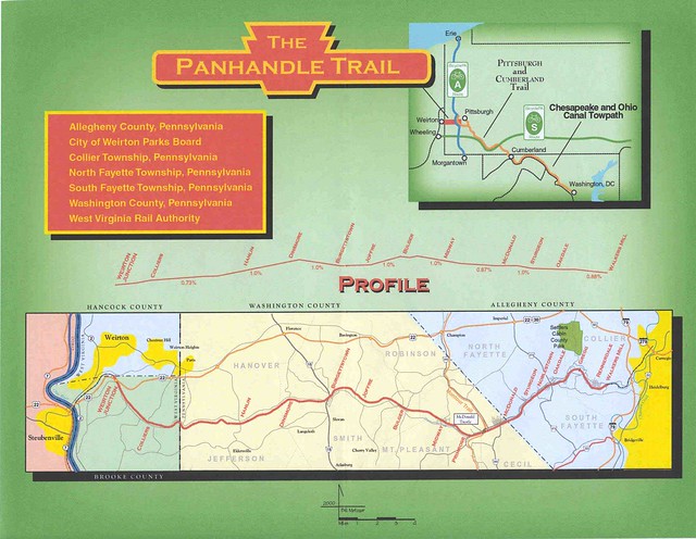
Rode 57 miles, doing the length of the Panhandle Trail twice in a figure-eight pattern.

Started at McDonald trailhead with R and S, riding west on the Panhandle. In previous years, the trail from Burgettstown to the WV border was rough and quite primitive, but it has recently been reworked and it's a much nicer trail now.

Saw like an infinity of butterflies, ate a few flying critters, saw some goldfinches, cardinals, orioles, one heron, a few feral cats and a tiny toad.

Rode west to Wierton, stopped for a break. We considered riding into town to see what's available but decided to avoid what would probably be a steep climb getting back to the trail. This is the Wierton trailhead:


Started the GPS and TrackMyRide to produce the map below, and began to ride east.


Entering Burgettstown we stopped at the new trailside restaurant, Walden's at 1709 Main. What an excellent trailside restaurant. When I asked our waitress Athena to fill my water bottles, she brought them back filled with icewater and very clean - she had scrubbed off the yearlong accumulation of nasty on the outside of those bottles.


I had a grilled ham and cheese with onion rings, it was excellent and quite reasonably priced. S had a sandwich with sweet potato fries and she said they may be the best sweet potato fries she's ever had. R had a BLT; everybody was pleased with their food.

As we were leaving we took a look at their desserts - next time, I think we'll be there for pie and coffee.

Refreshed and fed, back on the trail and road eastbound. I should mention that there's a convenience store where the trail passes the Midway VFD, their fire klaxon is visible on the trail. We rode to the McDonald trestle and continued beyond the Montour Trail to the eastern terminus of the Panhandle.

Many cool things on the eastern side of the trail, birdhouses and windmills and Nike sites and things like that.


Turned around at the eastern end and climbed back to McDonald, stopping at Hunner's Deli in Sturgeon for ice cream, which was excellent.

The newly refurbished Panhandle Trail is every bit the equal of the Montour Trail in terms of the quality of the trail surface, and although I'd avoided riding west of Burgettstown in the past I'll be out there more often from now on.

Thursday, May 3, 2012

SouthSide Works Plaza Opening, Bike Corrals

05/03/12 21m
Rode 21 miles, 88F. I'm ready for that "reversion to norm" thing with the high temps.

Big day for bicycling in Pittsburgh, several items of good news. The most immediate item of good news was the opening of the SouthSide Works (SSWx) Riverside Plaza, which permits the bike trail to pass along the river behind the American Eagle Outfitters corporate campus and HofBrau Haus.

(Except we're not supposed to refer to that location as SouthSide any more, we're supposed to call it the South Shore. Just like no more NorthSide, call it North Shore. Jagoffs, Jack Shore, whatever.)

This is a photo of SouthSide Workx Plaza while the first band was warming up, before the crowd started to build:


It was a cool opening event. HofBrau Haus was giving away pretzels and beer!, WYEP had two great bands playing, Mayor Luke Ravenstahl made an appearance. (okay, two out of three). Lots of people with well behaved dogs and kids; a really wide range of folks. Several members of the Pittsburgh Police bike squad were on hand.

The recent Bike Expo featured a bicycle-powered fruit smoothie maker, but today's event had bicycle-powered spin art machines, very nice:


The new plaza opening couldn't come at a better time. Until this was open, the trail had a multi-year kludge detour onto the "Tunnel Park", which nobody ever knew about. Two problems: lots of bicycles on the sidewalk outside of American Eagle Outfitters, and the Tunnel Park is about to be excavated and embiggened so they can widen the Panama Canal. Amazing.

We are uncertain as to the effect of the Tunnel Park excavation on the Saturday 10:00 Yoga-in-the-Park classes.

In other Pittsburgh bicycling news, paint striping and installation were started on the first three "parking corrals" aka "parking swaps" in which two car parking spots are re-purposed as on-street parking for 24 bicycles. Very leading edge.

Tuesday, May 1, 2012

Post Prandial Pedaling and Cable Stretch


05/01/12 246# 26m
Had lunch with a few old friends in our periodic Geezers 2.0 luncheon, then rode 26 miles on the Montour Trail. Nothing unusual other than truly great weather.

I've put a few hundred miles on the bike since a new drivetrain was installed, including new cables and housings, and there's been a bit of gear chatter and uncommanded shifts on the rear cassette which I attribute to the new cables stretching after use. I am not a derailleur guru, but I was bold enough to make a one-half turn on the cable adjustment, and then another half-turn later on.

When I got off the bike and back to the web, I read Sheldon Brown (RIP) on the topic and then found this video and it was pretty straightforward, just FYI:


What eludes me about cable stretch are the implications for civil engineering. When they build a suspension bridge, there aren't any adjusters for cable stretch built into the mechanism. If cables stretch after break-in, shouldn't the bridges sag? Conversely, if the bridges aren't sagging then the cables aren't stretching, and then what is this craziness the bicyclists are putting up with?

Sunday, April 29, 2012

Snuck a Ride on New Proto-Trail


04/29/12 35m

Rode 35 miles with loaded panniers. Started at Boggs and rode south-west. There were quite a few people out on the trail, even in the isolated sections that are usually empty. I was following one rider by about a minute, and when I reached the detour around MP20 the "rabbit" went straight ahead into the construction zone rather than taking the detour. I followed him, intrigued at what we'd see, and it seemed that the work crews were not there on Sunday and the new routing was sufficiently along to provide a nice ride.


In the photo above, the new train track will pass over the heavy-duty bridge where my bike is, and the trail will pass over a lighter bridge still bring built (on the left). Continuing along the rail-and-trail in progress, you can see where the railbed is and where the trail is; it looks like they're doing a very nice job.

Continued on the trail to the Morganza Road and Georgetown Road bridges. Signs on the roadway indicate that the roads will be closed for short periods this upcoming week, maybe that means the decks will be progressing. At Georgetown Road, instead of continuing on the Hahn Drive detour, I walked the bike up the bank (in the same manner as we once used there for trail access) and got right onto the trail. The detour is good and I'm glad we had it, but the trail is nicer.

I stopped at MP28.5, where the bridge observation decks look out over the stream (this is IMO one of the prettiest spots on the Montour Trail) and had a bar and a drink. Reversed course and stopped at MP25.5 to check out the campgrounds, I'll be spending a night there pretty soon as a final check on my camping gear.

Continued east, and at Venice I again eschewed the detour for the new trail-in-progress. The detour is good; it's well-marked and safe, and during the week I'll be using it again, but it was a treat to try "new trail".

At MP16 I encountered J and C on the trail, and we rode east together until I stopped at Boggs. Trail conditions were excellent, and it was a very nice ride.