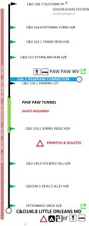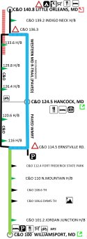
After leading a lot of bicycle tour groups from Pittsburgh to DC (and DC to Pittsburgh), we've developed a Trail Guide's ChartPack for the GAP and C&O trails.
| Greetings! Currently finishing the ChartPack and working on distribution. Any inquiries please email: vbush90@gmail.com |
Trail Guide's ChartPack for GAPCO: this package of overview charts and drilldown maps, bound into a single easy-to-use format (think: AAA triptik) provides more usable information in a single source for your Pittsburgh to DC bicycle trip. It reduces uncertainty, helps you respond to the unexpected, and makes it more likely you'll enjoy your ride. This flip-top guide fits easily in a bike jersey pocket or handlebar bag and is designed to avoid information overload.
- Presents both transit-style overview charts and detailed layout maps:
- the overview chart for each trail segment shows distances, key things to watch for, and the location of rest rooms, water, and food
- the drilldown maps for towns along the trail show lodging, shops, restaurants
- the overview chart for each trail segment shows distances, key things to watch for, and the location of rest rooms, water, and food
- Includes coordinates for road crossings and trailheads to simplify connecting with support vehicles or making unplanned extractions. An extra copy of this is provided for the driver of your support vehicle.
- Identifies areas of low- or no-cellphone coverage so you'll know in advance when you'll be incommunicado
- Highlights the "must-see" portions of each segment for riders who aren't going to ride every mile, but want to see the key sights before they hop into the support van
- includes three simplified strip maps for the rest of your group - helping them stay oriented about distances, towns, and facilities.
- includes optional transitions (Montour Trail, Southside Trail, Capital Crescent Trail, and the W&OD/Custis option) in case of closures or deteriorating conditions.

These are like Jepp Charts for the Great Allegheny Passage and C&O Canal Trail. Do you know the story of Jeppesen Charts? In 1934, airline pilot E.B. Jeppesen started compiling his own notebook of good things to know for each airport. He avoided unnecessary data and produced an easy to use guide. At first it was for his personal use, but other pilots saw the usefulness and Jeppesen started selling his notebooks out of his basement. The chart business grew and he quit his job as a Captain and focused on making charts.
There are other options! There are several map options available for people planning trips on the Great Allegheny Passage and the C&O Canal Trail. Gap-Map will mail you a free waterproof map of the GAP and C&O. The ATA TrailBook ($10) contains a map of the GAP and C&O. Trailheads, bike shops, and NPS facilities provide free paper maps of the respective trails.
Why buy our GAPCO ChartPack? Our GAPCO ChartPack is somewhat of an "artisanal cartography project"; it costs a bit more; we think it's better than anything else; you might find it wonderful. We've curated and designed the ChartPack to deliver the important information while avoiding the non-essentials. Not everybody is a map reader. We present important information in a readily usable format, avoiding chart-junk in the manner of Edward Tufte.
As trail tour guides, we believe you'll find great value in the GAPCO Chartpack. Most folks only make the DC-Pgh trip once, and you should be well-briefed before you start- rather than figuring most of it out during the experience. Considering the time, travel, and expenses involved you'll find this an excellent investment.
We will donate all of the proceeds from these sales to Operation Safety Net, which provides street medical care to the homeless, and to the Red Lantern Bikeshop which refurbishes bikes for under-privileged children in Braddock, PA.
Trail Guide's ChartPack for GAPCO
| ||||||
| Trail Strip Maps | Coordinates Page | fold-out Drilldown page | ||||
 |  |  |  | |||
We include three additional simplified strip maps (17" long, double-sided) presenting the trip from Pittsburgh to DC in a single, easy-to-use reference. Give each member of your group their own chart so they'll know where the next stop/ town/ facilities are. | ||||||
|
|
for the Map Geeks among us: We chose to use strip maps for the trail overview presentation because that's precisely the use-case for strip maps - a linear movement with little or no deviations, where the key task is orienting the map user and augmenting their situational awareness. We used area maps for the drill-down sections where the map user has multiple choices and needs to find distributed locations.
If you'd like to learn more about the use of strip-panel maps compared to large-area maps, check out Maps from Pedals to Planes, and from an academic perspective see MacEachren 1987, Evolution, Application, and Implications of Strip Format Travel Maps.


No comments:
Post a Comment